In May 2024, devastating floods hit Armenia’s northern regions, revealing alarming gaps in climate change adaptation. This article examines the impacts of flooding in the community of Alaverdi, the growing climate risks, and the need for immediate implementation of adaptation measures at the local level.

On the night of May 25-26, 2024, the rivers in Armenia’s northern basin and their tributaries overflowed their banks, flooding adjacent settlements, pastures and gardens. The affected areas included Tashir, Alaverdi, Pambak, Tumanyan, Stepanavan, and Gyulagarak in Lori Province, as well as Noyemberyan, Dilijan, and Ijevan in Tavush Province. All these communities were designated disaster areas by a government decree, which also defined their boundaries.
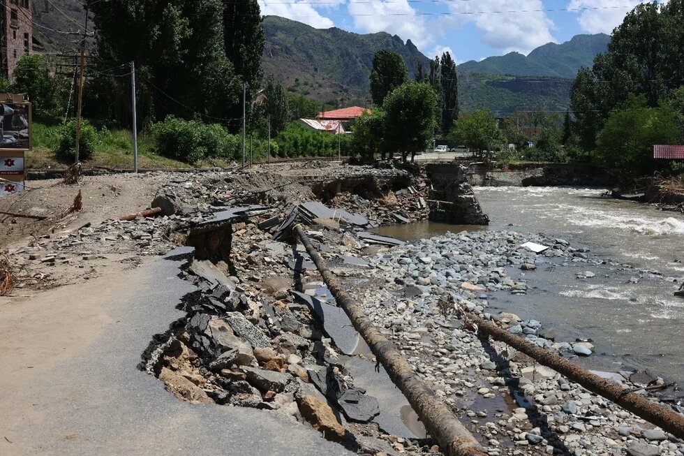
In his interview, Minister of Territorial Administration and Infrastructure Gnel Sanosyan emphasized the extensive damage, noting that huge funds are required to eliminate the consequences of the disaster. The floods damaged not only private property but also public infrastructure, including bridges, highways, utility poles, and gas and water pipelines. In addition, the rail sections from Sahahin to Ayrum suffered multiple breakdowns. In Lori and Tavush Provinces, 20 small and large bridges ― some crucial to local connectivity ― were destroyed, isolating several communities. The flooding also swept away Debed’s coastal gardens, cattle sheds, and garages, causing four fatalities.
Could the impact of the disaster have been mitigated? Are appropriate measures being implemented to build disaster-resilient communities?
Increased Flood Risk Due to Climate Change and Heavy Precipitation
As a landlocked mountainous country, Armenia is vulnerable to the effects of climate change, which exacerbates the frequency and severity of dangerous hydrometeorological events such as droughts, landslides, mudflows, and forest fires. These phenomena cause substantial damage to both the population and the economy. Experts predict that global warming will intensify the hydrological cycle, resulting in an increase in precipitation and flood risks.
The dynamics of air temperature in Armenia vary from season to season. The spatial distribution of precipitation is also highly uneven. From 1935 to 2016, the climate became drier in the northern (Vanadzor, Stepanavan), southern (Meghri), and central (Ararat Valley) regions, while precipitation rates increased in the Shirak Valley, Lake Sevan basin, and Aparan-Hrazdan region. From 1975 and 2016, the annual incidence of meteorological hazards in Armenia increased by about 40 cases per year.
The Environmental Monitoring Report for the first quarter of 2024 indicates that January and March experienced particularly high rainfall, with precipitation rates significantly exceeding the norm in different regions of the country.
In recent decades, the frequency and intensity of natural disasters have markedly increased due to climate change, both globally and in Armenia. From 1994 to 2014, floods, earthquakes, droughts, hail, spring frosts, and landslides inflicted damages exceeding $1.5 billion, negatively affecting living standards and the economy.
Studies conducted as part of the UNDP-GCF Armenia National Adaptation Plan project reveal that climate change has led to a significant rise in the frequency, intensity, duration, and extreme effects of hydrometeorological hazards in Armenia, including Lori Province. Moreover, one of these studies underscores that "observed and projected changes in the frequency and intensity of climatic hazards have, and will continue to have more devastating consequences than gradual changes in temperature and precipitation."
Although data for the second quarter have not yet been published, various publications of the Hydrometeorology and Monitoring Center (HMC) indicate that April 2024 was unusually dry, while May was marked by abundant rainfall. As of May 26, 2024, the amount of precipitation in Armenia for May exceeded the monthly norm by 180-230%.
On May 24, 2024, the HMC issued a warning of expected rains and thunderstorms across Armenia from May 24 to 26, with precipitation coming from the Mediterranean region. Heavy rains and hail were forecast in some areas, including Yerevan. On May 26, the HMC reported that the most intense rainfall occurred on the evening of May 25 and the night of May 26. In Tavush and Lori Provinces 40-55 mm of precipitation fell — 60% of the monthly average. Despite the heavy rains, there were no warnings of potential flooding in these regions.
As a result, the water level in the basins of the Debed and Aghstev rivers rose sharply by more than two meters compared to the previous day, which led to flooding of adjacent coastal areas, causing significant damage to nearby settlements.
Environmentalists point to massive deforestation as a contributing factor to such river overflows. Forests play a critical role in atmospheric processes and layers of the Earth at a certain depth. They create a link between all spheres, participating in the cycles of matter and energy. They regulate water flows by accumulating snow, retaining excess melt and rainwater, and improving the hydrological balance of water bodies, including groundwater. Forests reduce the rate of spring snowmelt as well as flood risks, which is essential for maintaining water balance and supporting hydropower. About 50,000 hectares of forest have been cut down in Armenia since the 1990s.
In addition, anthropogenic factors exacerbate the effects of natural disasters, including the narrowing of river channels in Alaverdi. Moreover, land use and infrastructure projects leave no space for water bodies. For instance, during the reconstruction of the M6 highway, stone masses excavated to widen the road filled the river and narrowed the channel.
Climate Risks and Adaptation Measures in Alaverdi
In 2021, the Disaster Risk Reduction National Platform (DRR NP, also known as the ARNAP Foundation) conducted a pilot study entitled “Identifying Climate Risks at the Local Level.” It aimed to assess potential climate risks across various communities, map significant threats, prioritize, and develop adaptation plans for different settlements.
The study identified several critical risks for Alaverdi, including:
- Debed River Flooding: Heavy rains near Sanahin Station could lead to flooding of structures and adjacent areas along the river. The study also revealed the vulnerability of numerous temporary structures and warehouses. The local sewage system discharges into the river, and the close proximity of sewage pipes to the river’s water level means that flooding could cause backflow of water into residential areas.
- Engels District: Residential houses and multi-apartment buildings located on slopes are highly susceptible to landslides.
- Sarahart District: Numerous dilapidated buildings as well as the road connecting the city center to the district are at significant risk of landslides..
- Sanahin District: Residential houses and internal roads are located in mudslide prone areas. The poor condition of internal roads exacerbates their vulnerability, potentially making them impassable during heavy rains.
- Spandaryan (“Factory”) District: Abandoned or inactive mining facilities in the area pose a risk of collapse.
These risks were confirmed in interviews with the community leader and residents of Alaverdi, who observed an increase in the frequency of Debed River floods and inundation of coastal areas.
Notably, the ARNAP study not only identified these climate risks but also recommended specific adaptation measures for Alaverdi, which were presented to the local government.
River Overflows and Flood Control
- Implement flood control measures in the vicinity of Sanahin Station, by strengthening and raising the banks of the Debed River, and regularly cleaning the riverbed. This will minimize the risk of flooding in adjacent areas.
- Redesign coastal areas and construct flood barriers to eliminate flood risks.
Heavy rains and landslides
- Inform residents about climate hazards, their potential impacts on households, urban infrastructure, and the environment, and provide safety guidelines. Ensure that at-risk populations are familiar with evacuation plans, responsible authorities, and their role in such situations.
- Establish volunteer groups and first aid teams, involving youth and collaborating with regional branches of the Rescue Service and Armenian Red Cross.
These activities are part of a broader effort to mitigate the effects of heavy rains and landslides.
The Alaverdi Community Five-Year Development Plan, prepared in 2023 identifies rockfalls, mudslides, landslides, and Debed River floods as significant natural or man-made hazards. Proposed measures include:
-Maintenance of storm drains
-Installation of new storm drains
-Cleanup of the Debed River
The Alaverdi Community Annual Work Plan (AWP) for 2023 includes thermal modernization of multi-story buildings as part of the climate adaptation program (nearing completion). The AWP for 2024 includes further renovation of multi-story buildings, as well as the construction of a 500 kW community solar power plant.
However, while storm drains may have been cleaned, no new drains have been constructed, and existing road drainage systems in Armenia are not capable of coping with higher precipitation volumes.
In addition, existing community or municipal plans lack comprehensive measures for evacuating and resettling affected populations, raising awareness about flood safety and compensating for damages.
Climate Change Adaptation in Armenia. National Plan and Vulnerability Assessment
Armenia’s climate is changing in line with global trends, but the nature and severity of climate change and associated hydrometeorological hazards are influenced not only by climatic factors but also by economic activities, infrastructure, as well as human and natural ecosystems (populations and properties at risk). The vulnerability of these systems further shapes the overall risk profile.
On May 13, 2021, the Government of Armenia approved the “National Action Plan on Climate Adaptation and List of Measures for 2021-2025” (Decree N749-L), designating Tavush and Shirak Provinces as pilot regions. The plan calls for developing climate change adaptation for the remaining eight provinces and submitting them to the Prime Minister's Office as an interim measure.
The National Action Plan aims to reduce vulnerability to climate change by building resilience and capacity, integrating adaptation programs into fiscal, regulatory, and development policies, and prioritizing climate-resilient investments.
The plan includes two policy packages. The first package is a set of cross-sectoral measures aimed at strengthening Armenia’s institutional capacity to identify, prioritize, and implement adaptation strategies, mobilize funding, and increase public awareness and understanding of climate adaptation at all levels.. The second package targets six priority sectors (water management, agriculture, energy, human settlements, healthcare, and tourism) and two pilot regions.
The National Action Plan emphasizes the need to assess existing and potential threats and their impacts in order to develop a comprehensive understanding of risks specific to different sectors and regions. Such strategy documents help countries identify and address emerging needs, challenges, gaps, priorities, and financial resources.
The impact of global warming and climate change on floods, landslides, and droughts is difficult to determine. Climate change may have caused the natural disasters that have intensified in the country in recent years, both directly and indirectly. The latter resulted in heavy precipitation, rapid snowmelt, unseasonal river flooding and other extreme events, which in turn contributed to more severe flooding and mudslides.
Thus, due to the frequency and magnitude of expected extreme events, climate change is likely to have a significant impact on various settlements and infrastructure and increase disaster risk. However, it is important to recognize that local factors such as land use practices, deforestation, and urban development also play a crucial role in amplifying these risks.
Assessing the effects of climate change at the local level is a complex task, but it is clear that natural hazards often exacerbate existing risks rather than creating new ones. As stated in the report “Identifying Climate Risks at the Local Level,” the systems most sensitive to climate change are those that have suffered significant damage as a result of human activities . Without urgent action to address anthropogenic vulnerabilities, technological reforms and investments alone may not be sufficient to effectively reduce risks and give new momentum to these systems.
Unimplemented Measures and Low Public Awareness
Although the “National Action Plan on Climate Adaptation and List of Measures for 2021-2025” was approved by government decree in 2021, the extent of its implementation at the local level remains unclear. Regarding Alaverdi, for which the ARNAP Foundation identified key climate risks in 2021, it is evident that almost none of the proposed disaster management measures have been implemented. Moreover, public awareness and understanding of climate change, its hazards, and mitigation strategies are at dismally low levels. These gaps in adaptation efforts are alarming; without widespread public understanding and engagement, the success of adaptation programs, even with advanced technological solutions, is unlikely.
Conclusion
The recent flooding in Alaverdi highlights the critical need for effective climate adaptation measures and response strategies in Armenia. The disaster exposed significant vulnerabilities, particularly in relation to infrastructure, and showed the lack of proactive measures to mitigate potential impacts.
The delay in addressing these vulnerabilities points to a broader issue. Despite the presence of a national action plan, its implementation on the ground remains woefully inadequate. The adaptation measures proposed by the ARNAP Foundation that could have mitigated major risks in Alaverdi have largely not been executed. The latter highlights a troubling discrepancy between planning and implementation, as well as between national policy and local actions.
Effective disaster management and mitigation is both feasible and necessary. The case of Alaverdi demonstrates that timely interventions, such as strengthening riverbanks, improving drainage systems, and conducting public awareness programs, can significantly reduce disaster damage. However, the current level of preparedness and public engagement in affected communities is insufficient. The lack of effective action and commitment at the local level undermines the potential success of climate adaptation strategies.
Overall, while Armenia has developed a national climate adaptation plan, its execution and community engagement at the local level are critically lacking. To effectively manage climate hazards, it is essential to integrate national strategies with local actions, raise public awareness, and incorporate adaptation measures into community planning and infrastructure projects. Only through these concerted efforts can Armenia expect to reduce vulnerability and mitigate the effects of natural disasters.
The content of the article is the sole responsibility of the author and can in no way be taken to reflect the views of the Heinrich Boell Foundation South Caucasus Office